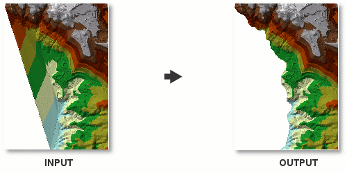
I'm trying to figure out how to remove only the outer boundary of a group of polygons. For instance, imagine I have a layer containing the map of the United States, where each state is its own polygon/attribute. I want to create a new layer that consists only of the boundaries BETWEEN states. In other words, all of the coastline and borders would be gone, but the state grid would still be present (only the coastal or border states would be affected). Is there any way of doing this?
What I'm trying to do is replace an inaccurate boundary edge with a more accurate boundary edge. The problem is that my accurate boundary edge doesn't include the interior polygon edges. So I'm trying to take the interior polygon edges from one layer and combine it with the accurate boundary edge of the other. Unfortunately the answer to the question the way I asked it results in multiple lines that no longer include the original attribute data for the original polygons. I now have a feeling I'm going about it in entirely the wrong way!
I ended using a combination of what Nir and Midavalo recommended. I used Polygon to Line (instead of Feature to Line) to turn my "state" and boundary layer into lines, then selected by attribute (Left_ID = -1) to remove the outer boundary. Then I copied and pasted my more accurate boundary line into this layer, and used Feature to Polygon to convert the new combines lines layer into Polygons. Then since I only had about 12 or so polygons I manually entered the appropriate attribute data into the new polygons. Problem solved.
Best Answer